heron's rest to torcross

south west coast path

10th may 2014

We're staying this week in a cottage called Heron's Rest, thanks to Classic Cottages. The cottage is set in a peaceful location, high above the Dart valley overlooking Dartmouth.

The weather forecast for today has been dreadful (but getting progressively better) all week and after heavy overnight rain it looks like I've got a thoroughly nice spring day to look forward to. Could be a bit blustery though.

Dartmouth high tide 15:49

Dartmouth low tide 08:59

tide times.jpg

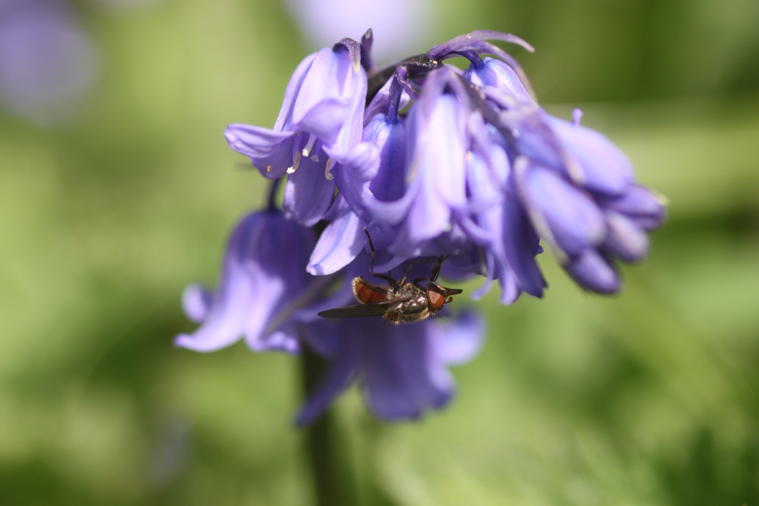
After packing my bag, I leave Heron's Rest for the walk through Long Wood down to the ferry crossing over the River Dart to Dartmouth. It's a lovely Spring day so I take advantage and photograph some of the spring flowers.

long wood

Just before leaving Long Wood I come across a sign warning of basking adders. Unfortunately the day is still young and so hasn't warmed up yet so I don't come across any.

After the delightful walk through Long Wood I reach the bank of the River Dart and catch the Higher Ferry (I was robbed of 50p for the crossing!) over to Dartmouth.

I amble through Dartmouth passing the Floating Bridge Inn and come across a Morgan Roadstar Brooklands Edition car parked on the waterfront.

morgan roadstar brooklands edition

warfleet creek

I continue ambling through Dartmouth passing the Ship in the Dock Inn, the Windjammer Inn and the George and Dragon before walking along the cobbled waterfront, passing Bayards Cove Inn and then through Bayards Cove Fort, a small Tudor artillery fort guarding Dartmouth's inner harbour. I climb steps to leave the waterfront and head through Warfleet Creek and towards St Petrox Church.

st petrox church

From here I head next door to Dartmouth Castle which, for over 600 years, has guarded the narrow entrance to the Dart estuary.

The path zig zags out towards Blackstone Point, Coombe Point and then Warren Point, passing secluded coves on the way before heading inland to reach a minor road. This road leads to the A379 which takes me in to Stoke Fleming where I pass the Green Dragon and St Peter's Church.

st peter's church

green dragon

I follow the A379 (think I've gone the wrong way!) out of Stoke Fleming and on to Blackpool Sands where I have a potter around the shingly beach. The Venus Beach Cafe can be found here.

blackpool sands

king's arms

I leave Blackpool Sands via a lovely woodland path and cross a steep grassy valley and then a rather circuitous route (needless to say I got lost!) to reach Strete where I pass the King's Arms (it seems to be closed and is to let) and see St Michael's Church in the distance.

woodland flowers

I follow the A379 out of Strete before a path takes me down to the Strete Gate picnic site from where I drop down onto Slapton Sands. I trudge along the beach which starts off sandy but soon becomes more shingly.

slapton sands

The wind has been blustery all day but seems to turn into a gale here and I can barely stay on my feet so I head back to the main road to try and find some relief, cross it, and drop down to a path that follows the road in front of Slapton Ley. There isn't any relief!

torcross

From here it should be an easy walk to the car park at Torcross, the destination for today's walk. Unfortunately, today it isn't an easy walk so I stumble around in the wind until I reach the car park where I shelter in a hide overlooking Slapton Ley for a bit.

slapton ley

I leave the shelter of the hide, head past the Sherman tank at the entrance of the car park and on to the Start Bay Inn (@StartBayInn) where I enjoy a yummy pint of Otter Brewery's Otter Ale.

otter ale

I leave the shelter of the hide, head past the Sherman tank at the entrance of the car park and on to the Start Bay Inn (@StartBayInn) where I enjoy a yummy pint of Otter Brewery's Otter Ale.

FLORA AND FAUNA

Flora and fauna encountered on the walk today includes :-

  • owls
  • magpies
  • no adders
  • chaffinches
  • robins
  • wrens
  • thrushes
  • empty snail shells
  • skylarks
  • bluebells
  • wild garlic
  • swallows
  • red campion

PODCAST

The podcast of today's walk is now available.  You can subscribe via the iTunes store or listen using the player below.


MARKS OUT OF TEN?

According to my phone I've walked 16 miles today (much further than I was expecting) which amounts to 32396 steps. Despite the wind for most of the day it has been a great day's spring walking with plenty of interest to see throughout the day. 9 out of 10.


View heron's rest to torcross in a larger map

uphill to shipham

west mendip way

18th april 2014


The weather forecast for the day looks to be fantastic, especially considering that it's Easter weekend. Can't complain!

Today's walk is  relatively local and starts on the beach at Uphill just outside of Weston-Super-Mare. I walk along the beach to reach the official start of the West Mendip Way at Uphill Marina. Skylarks are out in numbers singing their hearts out.

uphill beach

The West Mendip Way was opened on the 24th of May 1979 and a plaque at Uphill Marina commemorates the opening but is hidden away on the sea defence wall and is now obscured by ivy.

uphill marina

I pass a limekiln and then an explosives store before entering Uphill Nature Reserve and then walk through Walborough Nature Reserve where I encounter some friendly cows.

I get dumped briefly onto the busy A370 where the birds don't seem to mind the noise, before heading off on a side road, passing Coombe Farm. The way marks for the West Mendip Way seem to be non existent.

I turn left and climb the side of Purn Hill, a 6.1 Hectare nature reserve managed by Avon Wildlife Trust. There are plenty of butterflies flying around here but they are a bit flighty so I only manage to photograph a speckled wood.

purn hill nature reserve

The path leads towards Bleadon village and I take a break here at the church of St Peter and St Paul.

speckled wood butterfly

st peter and st paul

I've walked this walk three times now and, maybe I'm blind, but I've failed to find any decent way marks so once again I get lost trying to find my way out of Bleadon and end up passing the Queens Arms twice.

Eventually, after much swearing, I find myself on the roman road at the top of Hellenge Hill but it takes me close on an hour. I walk along the road and encounter some pigs, skylarks and robins.

hellenge hill

The road continues for about a mile before veering to the left to descend to Hutton. My path leads straight ahead instead, along a bridleway.  The bridleway descends for about 2 miles until it reaches Loxton village.

bridleway

I take a break here at Loxton Parish Church before descending to the busy M5 motorway heaving with Easter traffic.

loxton parish church

I cross the bridge over the busy motorway and head towards Webbington Hotel and Spa before heading along the road below Crook Peak. At a grassy area I begin the climb of the northern slopes of Crook Peak. I reach the top where I have buzzards for company and a decent view back over the motorway and Loxton village beyond.

view from crook peak

triangulation point

I climb to a triangulation point on the summit of Wavering Down at 211 meters above sea level, along the way passing sheep, ponies and cows and calves.

view from wavering down

I have some lovely views from up here.

I pass Hill Farm and then descend through woods where the wild garlic is just coming into flower to a car park and then onto the busy A38. I cross the road at a petrol station and then join a bridleway which leads towards Shipham.

On the bridleway I encounter my first primroses of the day before coming to a field full of sheep and lambs making a lot of noise.

The path crosses some fields and over a stream before descending to the village of Shipham where I visit the parish church of St Leonard and pass the Penscot Inn where my lift awaits.

shipham parish church


FLORA AND FAUNA

Flora and fauna encountered on the walk today includes :-

  • skylarks
  • chaffinches
  • robins
  • orange tip butterflies
  • speckled wood butterflies
  • tortoiseshell butterflies
  • cows
  • sheep
  • ponies
  • wild garlic
  • primroses
  • bluebells
  • dog violets

PODCAST

The podcast of today's walk is now available.  You can subscribe via the iTunes store or listen using the player below.

MARKS OUT OF TEN?

My pedometer app has failed me again so I'm going to have to find a more reliable one. It looks like I've walked 15.9 miles, mostly thanks to the help of the unscheduled diversion at Bleadon. It has been a beautiful spring day today and despite failing to find the correct path out of Bleadon the walking has been fantastic. 8 out of 10.


View uphill to shipham in a larger map

bluebell

a short walk around slimbridge

25th january 2014

Slimbridge is a wetland reserve managed by the Wildfowl and Wetlands Trust near the village of Slimbridge, Gloucestershire. Slimbridge lies on the estuary of the River Severn. It was opened on the 10th of November 1946 by the artist and naturalist Sir Peter Scott. The reserve was the first Wildfowl and Wetlands Trust centre to be opened and there are now nine reserves dotted throughout the United Kingdom.

It's a rather pleasant winter January day today so we head up to Slimbridge for a wander. Due to the recent bad weather I'm a little rusty with my 105mm macro lens so today's photos didn't turn out too well. Here's a few photographs from the walk :-

greylag goose

helebores

greater flamingos

lesser flamingos

emperor goose

demoiselle crane

latest sightings

Here's what Slimbridge sounded like today :-

FLORA AND FAUNA

Errrr ….. rather a lot today. Flora and fauna encountered on the walk includes :-

  • black headed gulls
  • bewick's swan
  • richardson's canada geese
  • common shelduck
  • long tailed tits
  • crested screamer
  • puna teal
  • south american comb duck
  • greylag geese
  • rooks
  • robins
  • blue tits
  • great tits
  • coscoroba swans
  • snowdrops
  • goldfinches
  • great spotted woodpecker
  • chaffinch
  • hellebores
  • moorhens
  • coots
  • greater flamingos
  • lesser flamingos
  • black-crowned cranes
  • red-breasted geese
  • emperor geese
  • demoiselle cranes
  • andean flamingos
  • james' flamingos
  • fat pigeons
  • mute swans
  • willow
  • bull rushes
  • alder
  • jackdaws
  • caribbean flamingos

DISTANCE WALKED

According to my phone I've walked  3.2 miles today which amounts to 6831 steps. 


View slimbridge in a larger map

bridport farmers' market

south west coast path

11th january 2014

west bay

weather forecast.jpg

Today's weather forecast looks like it will be fantastic, especially considering the amount of rain we've had recently, and does, indeed, turn out to be bright, sunny and warm. Must make the most of it as it doesn't look like it will last vey long.

Today is Bridport Farmers' Market day which is a perfect excuse for heading out to the South West Coast Path at West Bay. The farmers' market is held on the second Saturday of every month in the Arts Centre (@BridportArts).

bridport farmers' market

Producers attending the market today included :-


First up is a wander around Bridport (including stocking up on supplies at Leakers Bakery (@leakersbakery)), exploring the saturday market and along the way passing The Ropemakers, the George Hotel, the Woodman Inn, The Greyhound, The Bull Hotel and The Hope & Anchor

After that I head out to West Bay along the Monarch's Way to join the South West Coast Path. It's pretty muddy out so I squelch along the fields at a very slow pace before reaching Park Dean Holiday Park at West Bay.

west bay

After exploring West Bay for a bit - passing the George Hotel and The West Bay Hotel - I trudge along the beach to reach Freshwater Beach Holiday Park, enjoying the mild January weather.

west bay beach

Here I head inland slightly, walking through the holiday park - it's pretty dead at this time of year - and then through fields to reach Burton Bradstock. I turn left to walk through part of the village and then head towards St Mary's church. I cross the stream that burbles away here and then cross fields  to reach Hive Beach.

burton bradstock

st mary's

Often I'll continue walking along Cogden Beach before doubling back on myself, crossing fields to reach the National Trust car park above Cogden but today is a short walk day so I end my walk by the Hive Beach Cafe, which is closed this week for annual maintenance but is open for business again on Monday.

hive beach at burton bradstock

FLORA AND FAUNA

Flora and fauna encountered on the walk today includes :-

  • sheep
  • robins
  • lots of dogs
  • lots of gulls
10 out of 10.png

MARKS OUT OF TEN?

I've walked about 5.5 miles today. My pedometer app failed me again but it should be about 12000 steps.

Love Bridport.

Love West Bay.

Gorgeous weather.

10 out of 10.

We'll be back next month.


View bridport to burton bradstock in a larger map

I didn't do any recording today but below is a recording from farmers' market day back in October. It includes recording from Bridport itself, Bridport Farmers' Market, the river behind Palmers Brewery, West Bay, Harbour Amusements in West Bay, West Bay beach, St Mary's Church, Burton Bradstock and Hive Beach at Burton Bradstock.

west bay beach

west bay beach

exmouth to seaton

south west coast path

3rd october 2013


Today's weather forecast looks to be on the ropey side.

Turns out it was worse than forecast. It started raining heavily just before I reached Budleigh Salterton, I walked through a thunderstorm while going through Budleigh Salterton. After that the weather turned much worse and I walked through another big storm while going through Sidmouth and beyond. 

The rain finally relented just before I reached Branscombe and then it turned into rather a nice afternoon. By then I was soaked though! 

weather forecast.jpg

Today's walk starts at Exmouth and since there's a nice, sandy beach here I might as well stroll along it for a bit. I couldn't find any signs so lucked upon the coast path by going through Foxholes Car Park just before Orcombe Red Rocks.


exmouth

orcombe red rocks

A path rises out of Exmouth to reach High Land of Orcombe and the start of the Jurassic Coast, a World Heritage Site stretching 95 miles from here right the way around to Dorset. A sign gives details of the Jurassic Coast and a Geoneedle can also be found which was unveiled by His Royal Highness the Prince of Wales, in 2002. The Geoneedle is constructed from a variety of different stones, representing both the major building stones to be found on the Jurassic Coast and the sequence of rocks that form this part of the coastline.

jurassic coast sign

geoneedle

geoneedle

I stay up on the cliffs passing the Devon Cliffs Holiday Park and the Beachcomber Bar before dropping down onto the beach just before Straight Point. The Royal Marine Ranges is found on Straight Point and they were practising today so a lot of gunfire was disturbing the tranquility. I climb back onto the cliffs, passing the rifle range, to reach Littleham Cove where there should be some fine views of the lovely crumbling red sandstone cliffs but it was a bit misty and the sea was red with sand.

beach and rifle range

littleham cove

I keep well away from the edge of the crumbling cliffs and climb onto Beacon Hill. A trig point is found showing the height to be 423 feet.

The path continues through some woodland and it is around here that it started chucking it down so I had to don my waterproofs. A tarmac path leads in to Budleigh Salterton and its pebbly beach. It was still chucking it down so I saw very little of Budleigh Salterton except for a shelter which I stayed in for a few minutes as a thunderstorm passed by.

budleigh salterton

budleigh salterton

I head along the sea front in the pouring rain but can't see very much.

The River Otter and the Otter Estuary Nature Reserve are reached so I turn inland in order to cross the River Otter via a road and then head back to the coast over the other side of the river. I don't see any otters but there are plenty of noisy geese here. There should be some fine views back to Budleigh Salterton but it's still chucking it down and still a bit misty.

view back to budleigh salter ton

More red sandstone cliffs are climbed and the going from here to past Sidmouth is going to get pretty rough. Another holiday park is encountered at Ladram Bay and a series of red sandstone stacks can be seen offshore.

ladram bay

There are lots of grassy slopes here including at Peak Hill but the path eventually reaches a road which drops in to Sidmouth

As I make my way through Sidmouth it is blowing a gale as well as tipping down with rain so I duck inland a bit to try and get some shelter. It's not the weather for photographs!

After enjoying the delights of a wet and windy Sidmouth I cross a bridge over the River Sid before climbing back onto the cliffs via a tarmac path. It's quite a climb up here (525 feet) but there are some benches at the top to rest and admire the view. Well, I admired it last time I was here in 2005 but there's not much to be seen today. 

view back to sidmouth

The path continues past South Combe Farm and down some steps to Salcombe Mouth where there is a pebbly beach. The coast path however, heads inland before climbing up on to the cliffs again at Higher Dunscombe Cliff. Even on this filthy day the views are spectacular. Here can be found the Weston Plats where, in the 19th century, thanks to the unique micro-climate on these cliffs, local residents were able to produce early crops of flowers, vegetables and strawberries.

view from the cliffs

weston mouth

After a walk along the clifftops the path descends on some steps to the beach at Weston Mouth. The path climbs steeply yet again to the top of Weston Cliff and then passes Weston Wild Flower Meadow. Unfortunately it's the wrong time of year now to enjoy the butterflies but if I came at the right time I could see Brimstones, Orange Tips, Skippers, Common Blues, Marbled Whites, Meadow Browns, Painted Ladies, Clouded Yellows and Red Spotted Burnets.

The path ducks inland at Coxe's Cliff before heading over grassy clifftops and descends once again, this time to Branscombe Mouth. The 62,000 tonne container ship MSC Napoli was beached here in January 2007 after experiencing difficulties during a storm.  After containers started to get washed up on the beach, scavengers started arriving to 'recycle' the contents. Unfortunately there are no longer any spare motorbikes lying around! The anchor of the ship, weighing 14 tonnes, was presented to the people of Branscombe by the ship's owners and was installed here in July 2008.

msc napoli anchor

branscombe beach

The weather has now vastly improved so I'm able to enjoy the beach here before another climb takes me to the top of East Cliff and I enter another caravan park, the Sea Shanty Caravan Park and then the coast path heads through the Hooken Undercliff, formed in 1790 by a slump in the chalk cliffs. I'm thankful for the undercliff as it saves me a hefty hike to the top of the cliffs.

hooken undercliffs

hooken undercliffs

I zig zag back up to the top of the cliff and round Beer Head before reaching the village of Beer. The Anchor Inn is on the seafront at Beer, just by the slipway, but seems to be lacking any signage whatsoever today. I continue to reach the Jubilee Memorial Grounds before joining a road.

beer

beer

Following exceptionally wet weather in 2012, there was a cliff fall severing part of Old Beer Road along  which the South West Coast Path used to run. As a result Old Beer Road is closed for walkers. It looks like a new route is being completed as I'm diverted through some woods to reach the other side of Old Beer Road. From here I trudge wearily into the destination for today, Seaton. It's been a long day!


FLORA AND FAUNA

Flora and fauna encountered on the walk today includes :-

  • noisy geese
  • little egrets
  • kestrels
  • no otters

Podcast

The podcast of today's walk is now available.  You can subscribe via the iTunes store or listen using the player below.

podcast logo small.png

MARKS OUT OF TEN?

According to my phone I've walked a whopping 24 miles today which amounts to 51851 steps. Despite the atrocious weather for most of the day it has been a great day's walking with plenty of interest to see (or not) throughout the day. 9 out of 10.


9 out of 10.png

View exmouth to seaton in a larger map

exmouth